Approximate location of 45KT28 beneath the Wanapum Reservoir.
Drawdown Gallery

The Web Pubs
  Sunset Creek
    by C M Nelson
  Reflections
    by Jay Miller

The Paper Pubs
  Prelim. Report
  Sunset Creek
  Eratta
  Culture Change
  Solland Thesis

Supplements
  Correspondence
  Level bag tools
  2014 Drawdown
  Proj. Points
  Setting
  Excavatiions
  Field Profiles
  Features
  Camp Life
  Ranching
     remains

  45KT26

Catalogs
  Primary Catalog
     Nos 1-400
     Nos 401-4813
  ID Bone
  Level Totals
  Artifacts by
     level

  Artifact
    comp catalog

  Level Bag
     Artifacts

KT28 Home

Return to Chaz.org

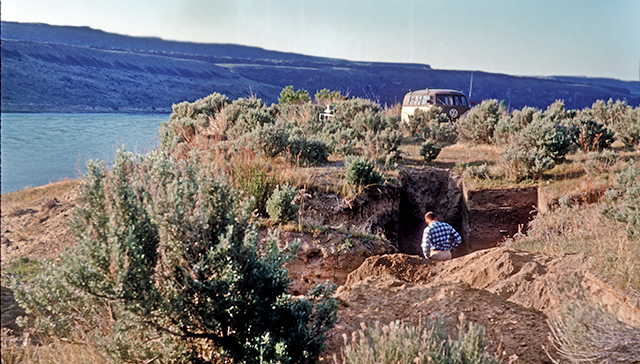
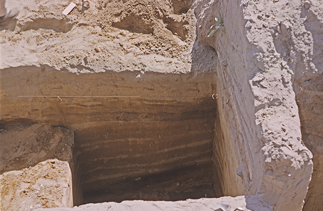
45KT28 ~ Gallery of Excavation Photos


The following photos were taken, primarily by Charles G. Nelson, during the excavation of 45KT28. The width of each image is 640 px, though most are displayed at a width of 390 px. To see the larger image, right click and select "view image".

A page from the notebook of Walter Barke that maps the House Pit 1 depression. The grid is in five foot squares. The larger numbers are elevations calculated from the nearest benchmark (see Fig. 4). Get Walter Barke's field notes for House Pit 1.


  Conventions
Abstract
Table of Contents
Letters
Figures & Tables
Acknowledgements
Introduction
Definitions
Setting
Cultural Record
 Introduction
 Vantage Phase
 Cold Springs
 Frenchman Spring
 
Quilomene Bar
 Cayuse Phase
  Characteristics
  Age
  Ethnography
  Salishan
  Stratigraphy
  Cayuse I
  Cayuse II
  Cayuse III
  Discussion
Summation
Models for
  Prehistory

Typology
Stone Artifacts
  Flaked Stone
  Percussion
  Ground Stone
Bone/Antler Tools
Shell Artifacts
Metal Artifacts
Raw Materials
Methodology
Rockshelters
References Cited


Witness section at House Pit 12. Spring, 1960.


The House Pit 15 excavation at low water.


The House Pit 15 excavation at high water. Spring 1961


First sun. Looking south at C. M. Nelson standing in the House Pit 15 excavation. The VW Microbus marks the location of our camp. Spring, 1961.


House Pit 15 excavated to the base of Component VIIH. The deadman used to anchor Booth's barge is still in place (see Ranching at 45KT28). Fall, 1958.


House Pit 15. The same stage of excavated seen above, as we penetrate for the first time the uppermost part of the fill in VIIC. Fall, 1958.


Looking west. The HP15 excavation the following year. The deadman, sans hawser, lies at the left foreground. The shovel leans against a wall that has been "explored" by collectors in the intervening period. The wall on the left has been undercut by the same activity. Spring, 1959.


Looking south. Excavation beneath Component VIIH down to the floor of Component VIIC. A number of the decorated pins (Fig. 83) came from the VIIC floor at the south end of the trench. Spring, 1959.


Night excavation in the VIIB/VIIF complex. Left to right, Alan Wood, David Rice, Kay Nelson, and C M Nelson. Spring, 1960.


Looking north. Night flash showing stratigraphic relationships among Cultural Components VIIA, VIIB, and VIIF. The outer wall of VIIB is just to the left of the "B" and extends upward until it is truncated by the floor of VIIF. The grayer areas at the top of the profile and on the side walls is the dried surface, the darker surface beneath freshly troweled. The three small blotches just to the left of the tape are bits of uncleaned surface. Spring 1960.


Looking north (see Fig. 5). The lower portion passes roughly through the center of VIIB. The bench at the left is a portion of the bench surrounding the inner floor of VIIB. The intermittent, horizontal stain about a foot below the level line marks the floor of VIIF, which truncates the fill above the VIIB floor. Notice that the early fill above the VIIF floor are centered in about the same place as those above the VIIB floor, suggesting that VIIF cleaned out and slightly expanded the depression left by the VIIB house. However, the 1948 flood silts fill a depression which is centered far to the right (east) of the earlier depressions. There is no structural evidence of a newer house to accompany this depression, which suggests that the depression left by the VIIF house was filled on it's south and west sides by sediments dumped there when the pit housing the VIIH house was excavated. Spring 1961.


Looking north. The position of soil samples taken from the profile in the image immediately above. Spring, 1961.


Looking north. Profile from 14L2 (left) to 14L1 (right) near the margins of VIIB and VIIF. Spring 1960.


Looking northeast at Component VIIA from 10L1 to 10R1. Spring, 1960.


Unearthing the edge of a rock feature within VIIA. Left to right, Kay Nelson, C M Nelson, and Alan Wood. Spring, 1960.


Accumulation of large rocks in the upper portion VIIA.


Looking west (see Fig. 5) at the profile along the CL line between 11CL and 12CL. VIIA is broken on the right by the wall of VIIB. The lighter colored sediments below VIIA contain remains from CCVI, the Quilomene Bar Phase component. Spring 1961.


Looking southeast at over Test Area 8 to Test Area 10 in the CCVI horizons. Test Area 11 is the hole in the wall at the left, partially excavated. The water is rising and we will soon be flooded out. Quilomene Bar Phase. Spring 1961.


Draft of a figure that was excluded from the published report. This figure shows the Test Areas used to define Components I, II, IV, V, and VI beneath the House Pit 15 area excavations. Their positions are shown in relation to the centerline grid used in excavating CCVII. Overlapping test areas represent different excavation seasons.


Looking west at the section beneath VIIA and the CCVI horizons. The dark horizon just visible at the base is CCIV. Quilomene Bar Phase overlying Frenchman Springs Phase. Spring 1961.


A closer look at the sounding imaged above showing IV more clearly. CCV lies in the sand directly above the dark stain. Spring 1961.


Looking north-northeast beneath VIIB at C M Nelson identifying the upper boundary of CCV. Spring 1961.


Looking east at CCI and CCII where they are draped over an early distributary channel of Sunset Creek. Vantage Phase. Spring, 1962.


Looking northwest at the 8R3-8R1 profile through CCVIID in Housepit 7. Spring 1960.

TOP

LAST REVISED: 20 APL 2022